Навчально-науковий інститут архітектури, будівництва та землеустрою
Explore our collection of items
Participatory planning of student campuses. Case studies: Poland and Ukraine
This article analyzes participatory planning as a tool for optimizing resources and increasing us...
Art as an Existential Means of Perception and Experience of the Tragedy of War
У статті аналізується роль мистецтва під час російсько-української війни (2022–2025) як інструмен...

Динаміка вертикальних рухів земної поверхні Придніпровської низовини
Здійснено аналіз динаміки вертикальних рухів перманентних супутникових станцій земної поверхні Пр...
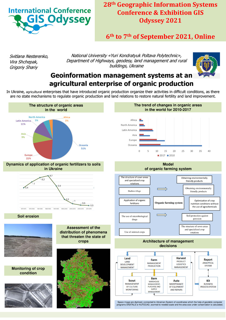
Geoinformation management systems at an agricultural enterprise of organic production
In Ukraine, agricultural enterprises that have introduced organic production organize their activ...
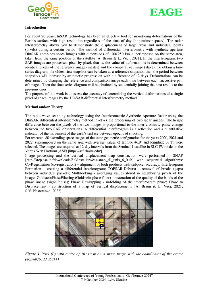
Accuracy of determining vertical deformations by the method of differential interferometry
With the development of satellite SAR interferometry, it became possible to remotely obtain infor...
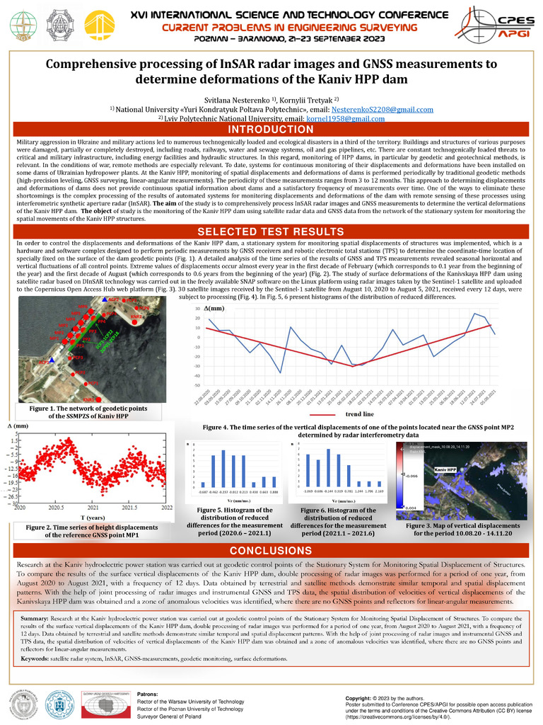
Comprehensive processing of InSAR radar images and GNSS measurements to determine deformations of the Kaniv HPP dam
Military aggression in Ukraine and military actions led to numerous technogenically loaded and ec...
Satellite Monitoring of Technogenically Hazardous Areas in Poltava Region
Over the past half-century, Poltava region has undergone significant territorial changes that hav...

Особливості розрахунку клеєних дерев’яних балок
Стаття 2025/12/18

Керованість самостійної роботи студентів в умовах викликів сьогодення
Стаття 2025/12/18
Participatory planning of student campuses. Case studies: Poland and Ukraine
This article analyzes participatory planning as a tool for optimizing resources and increasing users' social capital by studying the opinions of architecture students about their learning environme...
Стаття 2025/12/18
Art as an Existential Means of Perception and Experience of the Tragedy of War
У статті аналізується роль мистецтва під час російсько-української війни (2022–2025) як інструменту виживання, терапії та свідчення. В екстремальних ситуаціях, таких як війна, художня творчість ста...
Стаття 2025/12/18
Динаміка вертикальних рухів земної поверхні Придніпровської низовини
Здійснено аналіз динаміки вертикальних рухів перманентних супутникових станцій земної поверхні Придніпровської низовини на основі даних ГНСС–вимірів і дистанційного зондування Землі. Визначено зміщ...
Стаття 2025/12/17
Органічне землеробство як засіб охорони ґрунтів
Стаття 2025/12/17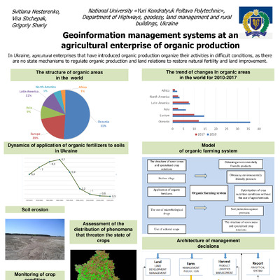
Geoinformation management systems at an agricultural enterprise of organic production
In Ukraine, agricultural enterprises that have introduced organic production organize their activities in difficult conditions, as there are no state mechanisms to regulate organic production and l...
Стаття 2025/12/17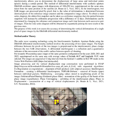
Accuracy of determining vertical deformations by the method of differential interferometry
With the development of satellite SAR interferometry, it became possible to remotely obtain information about deformations of the Earth's surface. Differential Interferometry Synthetic Aperture Rad...
Стаття 2025/12/17
Strength investigation of adgesive joints between concrete and steel
Стаття 2025/12/17
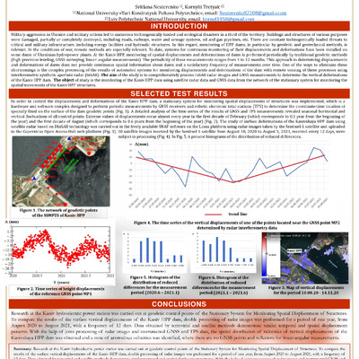
Comprehensive processing of InSAR radar images and GNSS measurements to determine deformations of the Kaniv HPP dam
Military aggression in Ukraine and military actions led to numerous technogenically loaded and ecological disasters in a third of the territory. Buildings and structures of various purposes were da...
Стаття 2025/12/17
Використання технологій RTK у земельному кадастрі
Стаття 2025/12/17
Satellite Monitoring of Technogenically Hazardous Areas in Poltava Region
Over the past half-century, Poltava region has undergone significant territorial changes that have affected land use and the state of the environment. The number of areas with a high level of techn...
Стаття 2025/12/17